Understanding Garmin’s Chart Types: Navigation, Fishing, 3D, and More

Garmin chartplotters and fish finders don’t rely on a one-size-fits-all approach when it comes to on-screen mapping. Instead, they offer a range of chart views—each tailored for specific tasks like safe navigation, detailed structure scanning, or visualizing terrain in three dimensions.
The different chart types aren’t just visual options—they’re built with distinct data layers and rendering techniques that serve different functions. Understanding how to interpret each one, and when to use it, can significantly improve your situational awareness, fishing accuracy, and overall efficiency on the water.
In this guide, we’ll break down the primary chart views available on Garmin marine units, including the Navigation Chart, Fishing Chart, Perspective 3D, Mariner’s Eye 3D, and Fish Eye 3D, and explain how each one works beneath the surface.
Navigation Chart
The Navigation Chart is the most detailed and data-rich chart view available on Garmin chartplotters. It’s built to support safe piloting and trip planning by presenting a full suite of nautical chart data layered over your position in real time. This view draws from the underlying Garmin Navionics+™ or BlueChart® g3 data, depending on what’s preloaded or installed.
What It Displays
- Aids to Navigation – Includes buoys, beacons, lighted markers, and dayboards, complete with characteristics like color, flashing intervals, and range.
- Depth Soundings and Contour Lines – Shows depth in feet or meters with high-resolution contours based on chart data and user preferences.
- Tide and Current Stations – Dynamic tide arrows and station info appear directly on the chart, giving you real-time info tied to GPS date and time.
- Hazards and Obstructions – Rocks, wrecks, submerged pilings, and other charted hazards are clearly marked, often with interactive callouts.
- Navigational Infrastructure – Features like channels, anchorages, restricted areas, marina icons, fuel docks, and ramp locations are all visible.
- Chart Symbols and Color Shading – Uses international-standard symbology (per IHO S-52) and shading to distinguish safe vs. shallow waters, navigation limits, and depth transitions.
When to Use It
This view is best used when you’re actively navigating or planning a route—especially in unfamiliar waters, around commercial traffic, or when precise knowledge of regulatory zones and hazards is critical. It’s the default view for most users cruising or running offshore routes, thanks to its depth and accuracy.
The Navigation Chart is also the view where you’ll typically lay down waypoints, create routes, and access overlays like radar (if installed) or AIS targets for vessels broadcasting position.
Fishing Chart
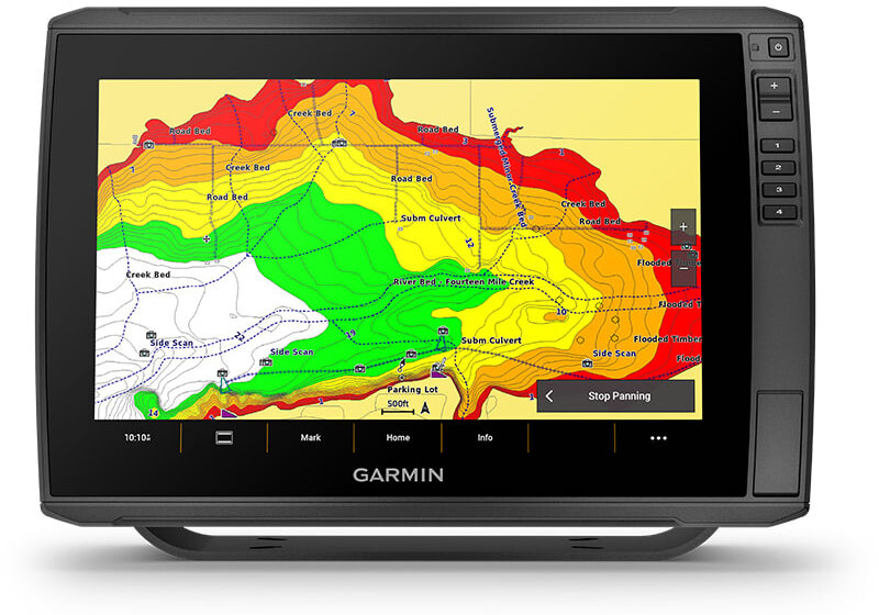
The Fishing Chart is a simplified yet functionally powerful view designed specifically for anglers. It removes many of the navigational elements found in the Navigation Chart—such as buoys, regulatory markers, and traffic separation schemes—to focus solely on bottom structure and bathymetry. This makes it easier to identify key features that hold fish, such as ledges, humps, drop-offs, and holes.
What It Displays
- High-Detail Contour Lines – Depending on your chart data, the Fishing Chart can show 1-foot contours or tighter where available, revealing fine-grain changes in bottom topology that can be missed on broader navigation-focused maps.
- Bottom Composition and Structure – While this chart doesn’t directly show substrate type (like rock vs. sand), it makes subtle contour variations much more readable, helping anglers interpret where structure transitions or depth breaks occur.
- Depth Soundings – Static depth soundings remain visible, but are less dominant, allowing contour density to take visual priority.
- Custom Shading – Depth range shading and relief shading (if available) can be applied to highlight key depth bands or bottom relief, making it easier to identify productive zones based on the species you’re targeting.
- Waypoints and Tracks – Like the Navigation Chart, this view still supports overlays for marked waypoints, routes, and tracks—so you can fish a ledge and return to the exact same drift line or drop.
When to Use It
The Fishing Chart is your go-to view when anchoring, drifting, trolling, or scouting structure. Because it eliminates visual clutter, it gives you a cleaner and more intuitive picture of the bottom—especially useful in areas with complex contours, like creek channels or offshore ledges.
It’s also the preferred view when using sonar overlays like Garmin Quickdraw Contours, as those user-generated depth maps become much easier to interpret in a simplified visual environment.
For anglers who rely on fine-tuned bottom reading—particularly for species like bass, grouper, or snapper—this chart view offers the visual clarity and focus needed to pick apart structure with precision.
Perspective 3D
Perspective 3D is a dynamic chart view that presents a three-dimensional rendering of your surroundings from a viewpoint just behind and slightly above your vessel. Unlike top-down chart views, Perspective 3D simulates what it would look like if you were watching your boat move across a 3D landscape—giving you a more intuitive sense of direction, terrain, and navigation.
This view combines standard chart data with your vessel’s heading, GPS position, and orientation to create a live, real-time visualization of the marine environment.
What It Displays
- 3D Terrain and Bathymetry – Depth contours and underwater structure are rendered in perspective to show hills, drop-offs, and bottom formations with a visual depth effect.
- Navigation Aids and Markers – Essential nav elements like buoys, channel markers, and hazard zones are displayed in spatial relation to your position.
- Land Elevation and Shorelines – Landmasses and shorelines are elevated in 3D, giving you a clearer sense of scale and relative distance—especially useful when operating near complex coastlines or unfamiliar inlets.
- Vessel Icon and Heading Line – Your boat is shown as a 3D icon with a projected heading line, giving you a clear visual of where you’re going relative to upcoming contours or hazards.
- Waypoint and Route Overlay – Waypoints and routes appear along the 3D terrain, which helps with visual route-following and identifying upcoming waypoints before you reach them.
When to Use It
Perspective 3D is especially useful in shallow, contour-rich environments where visualizing depth change is key—like bays, inland lakes, or reef systems. It also shines when navigating inlets or channels with tight turning radii, where a traditional top-down view can make it harder to judge spatial relationships.
While not a replacement for standard navigation views, it’s an excellent supplement—especially for visual learners or newer boaters who benefit from seeing the underwater terrain laid out more naturally.
Many users also rely on this view when fishing new areas, as it gives a visual preview of how bottom structure changes ahead of the vessel. When paired with sonar or Quickdraw data, it becomes a powerful scouting tool.
Mariner’s Eye 3D
Mariner’s Eye 3D is a forward-facing, above-the-water 3D chart view designed to enhance situational awareness and visual navigation. Unlike Perspective 3D, which focuses on underwater terrain, Mariner’s Eye 3D emphasizes what you would see from the helm—a “pilot’s-eye view” of the world around your vessel.
This view is particularly useful when you’re operating nearshore or in congested waterways where landmarks, aids to navigation, and shoreline orientation are just as important as depth contours.
What It Displays
- 3D Land Elevation and Shorelines – Terrain, coastlines, and islands are rendered in three dimensions with vertical relief. Hills, cliffs, and other topographic features are displayed proportionally, giving a real-world feel to the chart.
- Aids to Navigation – Buoys, beacons, daymarks, and lights appear as 3D objects in their real-world positions. Most are clickable for additional information (light characteristics, sound signals, etc.).
- Water Depth Coloring and Contours – While underwater topography isn’t as detailed as in Fishing or Perspective views, Mariner’s Eye still shows gradual changes in depth using color shading and contour lines.
- Navigation and Safety Zones – Marked areas such as restricted zones, anchorages, and no-wake areas are visualized in spatial context, helping you plan routes that stay compliant and safe.
- 3D Boat Icon with Heading and COG Lines – Your vessel is displayed with both heading and course-over-ground indicators, helping you orient yourself in real time.
When to Use It
Mariner’s Eye 3D is ideal for coastal cruising, inshore navigation, or any situation where being able to visually interpret land-based references is helpful—like entering harbors, maneuvering near docks, or running alongside irregular shorelines.
Because it offers a more realistic, intuitive view of the environment, it’s especially useful for boaters unfamiliar with an area. When paired with radar or AIS overlays, it also helps in visually identifying targets and plotting safe tracks in busy or narrow waters.
While not typically used for sonar-intensive fishing, this view excels at navigational awareness in close-quarters or unfamiliar routes, offering a layer of spatial understanding that top-down charts can’t always provide.
Fish Eye 3D
Fish Eye 3D offers a unique underwater perspective, simulating what it would look like if you were submerged beneath your boat and looking at the surrounding structure and sonar returns in a three-dimensional space. It’s not just a visual gimmick—this mode leverages your sonar data (especially when paired with Garmin CHIRP or Panoptix/LiveScope systems) to create a real-time 3D rendering of the underwater environment.
This chart view is particularly helpful for anglers and divers who want to interpret bottom features, fish targets, and bait schools in a more spatially accurate way.
What It Displays
- 3D Underwater Terrain – The seafloor or lakebed is rendered in perspective, based on chart data and sonar returns. It shows structure like drop-offs, humps, points, and holes in three dimensions.
- Sonar Echoes as Fish Targets – Detected fish appear as dynamic targets in the water column, with position and depth relative to the boat and seafloor. The visual format helps differentiate bait from gamefish and visualize school movement.
- Boat Position Above Water – Your vessel is rendered on the surface, giving you a point of reference for where you’re looking and how far objects are from your current position.
- Heading and Depth Perspective – You can adjust the angle of the virtual camera, rotating and tilting to view different parts of the structure and water column from below, ahead, or behind the boat.
When to Use It
Fish Eye 3D is especially valuable when using Garmin Panoptix or LiveScope, as it visualizes what’s happening under and around the boat in real time, rather than relying solely on traditional scrolling sonar. It can be useful for:
- Interpreting complex bottom structure
- Identifying suspended fish and tracking bait movement
- Understanding fish depth and relation to structure in a single glance
While it may not replace traditional sonar views for all users, Fish Eye 3D adds a valuable layer of spatial understanding—especially for anglers who rely on vertical presentations, live sonar tracking, or precise positioning over submerged features.
Error, no group ID set! Check your syntax!Final Thoughts
Each chart view available on Garmin’s fish finders and chartplotters serves a distinct purpose, and understanding the differences is key to making the most of your unit. Whether you’re navigating a tricky inlet, tracking structure for a drift, or watching fish move in real time, the ability to switch between tailored views can give you a serious edge.
- The Navigation Chart delivers full situational awareness for safe piloting.
- The Fishing Chart strips things down to help you zero in on bottom contours and structure.
- Perspective 3D and Mariner’s Eye 3D offer immersive spatial views that make interpreting terrain and planning routes more intuitive.
- And Fish Eye 3D brings sonar returns into a whole new dimension—literally—especially when paired with advanced sonar systems.
Garmin builds these views with different types of users in mind, from the weekend cruiser to the tournament angler. Once you get familiar with how each one works, you’ll start to use them not just for convenience, but as core tools in how you navigate and fish.
Search
Recent Posts
By Noah Corcoran When it comes…


